Slate Peak Lookout
US 359, WA 40
Lookout Details
| Registry Numbers | US 359, WA 40 (view other lookouts in United States, Washington) |
| Date Registered | November 4, 2000 |
| Nominated by | Ray Kresek, Washington Registrar |
| Location |
Okanogan National Forest Okanogan County, Washington |
| Coordinates |
N 48° 44.508' W 120° 40.764' (view using Google Maps) N 48° 44' 30" W 120° 40' 46" N 48.741800° W 120.679400° |
| Elevation | 7,308 ft (2,227 m) |
| Administered by | U.S. Forest Service |
| Cooperators | Methow Valley Ranger District |
Description
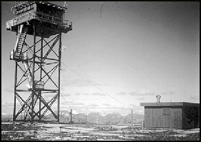
Located at the end of the highest road in Washington, Slate Peak Lookout was first constructed as a gable roof cupola in 1924. In 1954 an L-4 ground cab was moved intact from Leecher Mountain, and two years later the Air Force removed 40' from the summit (including the lookout) for a radar station that was never built. The lookout was put on a 41' tower. With stunning views of the North Cascades, it is maintained for emergency use.
Map
Change Basemap
Photos

February 2010 photo by John Scurlock