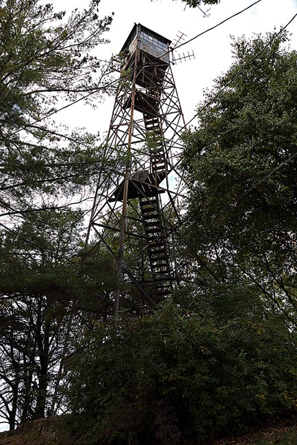
Mooresburg (Flat Gap) Lookout
US 990, TN 10
Lookout Details
| Registry Numbers | US 990, TN 10 (view other lookouts in United States, Tennessee) |
| Date Registered | March 14, 2014 |
| Nominated by | Ron Stafford |
| Location | Hawkins County, Tennessee |
| Coordinates |
N 36° 25.383' W 083° 11.817' (view using Google Maps) N 36° 25' 23" W 083° 11' 49" N 36.423056° W 083.196944° |
| Elevation | 2,585 ft (788 m) |
| Built | 1937 |
| Administered by | Tennessee Division of Forestry |
Description
This tower was built in 1937 and originally known as the Flat Gap tower. Its name was later changed to Mooresburg.
Map
Change Basemap
Visit Reports
April 20, 2008: Jeff Flanary
Condition |
|
| Needs paint? | Yes |
| Shutters OK? | No Response |
| Condition of wood OK? | Yes |
| Stairs OK? | Yes |
| Glass intact? | Yes |
| Good condition? | Yes |
| Comments: | Cab is rusty, roof needs work, most glass intact, stairs look ok, bottom run has been removed. Two outbuildings in pretty good shape, new paint. No fence. Nice Forest Service sign. |
Electronics and Enroachments |
|
| Are electronic sites enroaching on tower? | Yes |
| Other enroachments? | Two other towers at this site, antennas all over the tower itself as well as a small solar panel. |
Access and Signs |
|
| NHLR sign posted? | No |
| Directions to tower signed? | No |
Staffing |
|
| Staffed? | No |
Opportunities for Volunteer Support |
|
| Volunteers staffing opportunities? | No Response |
| Volunteer maintenance opportunities? |
No Response
Not sure about maintenance support.
|